

Water Levels & SEPA Graphs - 1. The Basics
Roger Dowsett
Added on 03 February 2025
First published on AlnessFishing.com 24/04/12.
Historic water levels for the past 54 hours are published daily each morning for most salmon rivers in Scotland on the SEPA website.
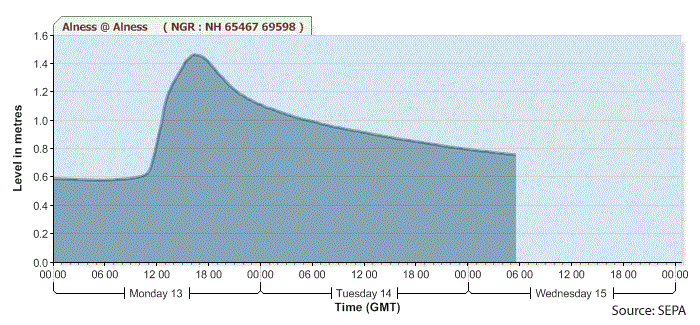 Here's an example for the RIver Alness from June 2011 showing the classic water level profile of a spate; a sharp rise to a peak, followed by an initially fast drop from that peak, then dropping ever more slowly to form the receding limb of the spate that may last from 1 to 5 days.
Water levels for the River Alness are measured in a pool in the town of Alness. Summer low (defined as the water level exceeded 95% of the time) in that pool is 0.4m (40cm). In this example the background water level is 0.6m, so before the spate the river level was approximately 20cm above summer low (+ 8in). The river then rises quickly, peaking at over 1.4m (+ 3ft 3in), before starting to drop - the last recorded water level is 0.76m (+ 1ft 2in).
The magnitude and duration of spates on the Alness varies considerably. Any rise in water level peaking at over 0.6m (+ 8in) can be considered a spate: less than 0.85m (+ 1ft 6in) a small spate; over 1.3m (+ 3ft) a big spate.
The best conditions and water levels for catching salmon on the Alness are described in the next tips article, but anything over 1.3m should be considered as 'unfishable', anything under 0.45m is difficult and under 0.4m extremely difficult.