

Salmon Catches & River Levels - 2
Roger Dowsett
Added on 15 July 2025
Determining River ‘Height’
SEPA river level gauges are installed on most Highland rivers, providing online access to up-to-date river levels for the past 5 days.
Looking at a river level graph for the first time for a new river can be difficult to interpret though. Every gauge pool is different and the y-axis (level) values vary considerably. The graphs have no base level and SEPA do not provide a separate ‘summer low’ level, and the y-axis autoscales which can make small events appear more significant.
If the SEPA graph shows a current value of 0.6m, what does this mean – a drought, a spate, the height that the river is above its minimum level? We might get a clue from the 5-day history, if it’s flat-lined for 4 days before a spate, but we are unlikely to be that lucky when we need it!
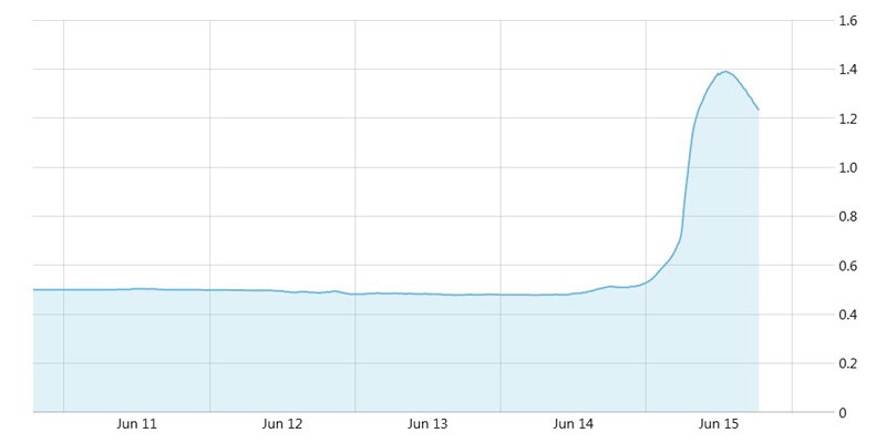
Wick River, June 2025
For anglers, the 'height' is the level that the river is running at, above its normal minimum level. If we know the minimum level, then we just need to subtract that value from the current level on the graph. In the Wick River example above, summer low appears to be about 0.5 m and the spate peaked at 1.39 m. The river therefore reached a height of +0.89 m or +2 ft 11 in.
There are different interpretations/definitions of minimum level, but they all amount to the same thing.
Natural Flow Rivers
On natural flow rivers, ‘summer low’ is the flow rate (river level) exceeded 95% of the time (Q95). Put another way, its the low level reached for 18 days per year (most likely in summer). There are many rivers with dammed lochs from which flow can be regulated to provide compensation flow, which can with adequate reserves, result in a higher summer low flow rate than might occur naturally.
Hydro Rivers
On hydro rivers, flow is always regulated and the minimum flow rate is referred to as the Hands-off Flow (HOF), or more commonly by anglers as ‘compensation level’. For new hydro schemes this is determined by SEPA and likely to be around Q95 but may vary depending on the river’s ecology. For historic schemes in the Highlands, there is great variety in minimum compensation levels (and in some cases the provision of freshets), depending on what was negotiated at the time of development, and this level may also vary by month during the fishing season.
The Gauge
Depth gauges on rivers are usually ‘zeroed’ to a level similar to summer low, derived over an extended period of time through observation, before electronic measurements were available.
There is no indication of summer low or other minimum level on the SEPA site, other than a graph of high, normal and low ranges, which are of limited use for anglers.
Currently we don’t have access to sufficient historical river flow & level data to calculate Q95, so we have taken an empirical approach to provide a minimum flow level for each river.
SEPA Gauge Pins – Base Level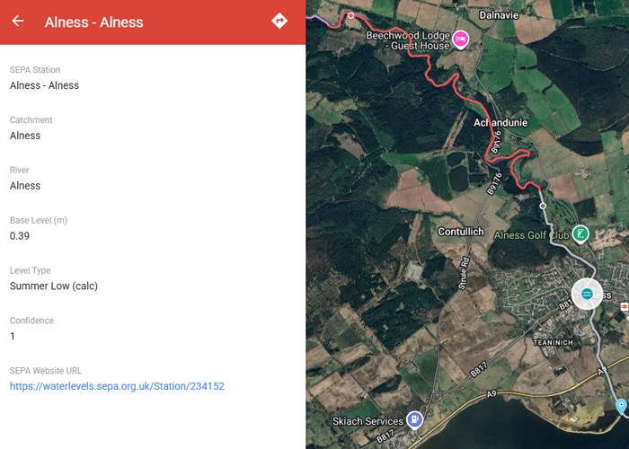 We have been reviewing river level data for all Highland rivers through this spring and early summer (this spring the driest for over 50 years). Where possible, we’ve determined a 'base level' for each gauge and we have just added this as a new field in the pin data for most of the SEPA gauges.
There are also 2 additional fields which define the type of base level e.g. summer low or compensation flow, and confidence of measurement (1 = high, 2 = moderate, 3 = low).
Using the lowest levels observed during our initial evaluation period may actually give a level lower than the normal ‘summer low’, but its accuracy is likely to be within 1 cm, which is unlikely to be significant other than in exceptional circumstances. At 10-15 cm/4-6 in above summer low it will not be too important and at higher than +30 cm/12 in, it's irrelevant.
We will continue to monitor future levels to fine tune our initial values and determine values for additional gauges.