

Salmon Catches and Conservation Status
Roger Dowsett
Added on 05 February 2025
Salmon Catches on the HiFly Map
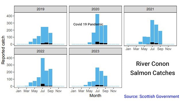 Version 1.1.1 of the HiFly Map includes new salmon catch data for most river/loch systems. This data is presented on the map as histograms of salmon catches by month for the 5-year period up to and including the 2023 season and can be found via the map pins on the Salmon Fisheries layer.
Providing salmon catches for rivers or beats has been on the wish list from the beginning but it is not easily achieved. Catches by beat is a pipe dream, as many if not most proprietors experiencing declining catches, do not want to advertise it.
Each proprietor does however, have a legal requirement to report their catches to the Scottish Government. Getting information on a per beat basis though, would likely require countless Freedom of Information requests.
Catch records for individual rivers are available from the Scottish Government from 1952-2023, but the data set comprises 55,000 records and more than 1 million data fields, so it would be quite a job to sift through that lot to produce our own figures!
Every August, the Marine Directorate publishes its proposed river gradings (Conservation Status) for the following season. At this time, it releases a summary of individual river/loch system catches by month for the past 5 years, which they have used as part of their model i.e. 2023 catches only become available in 2024, and are then used for proposed river gradings for the 2025 season.
This is the most current and complete catch data readily available to us, and so we have incorporated > 100 of these graphs into our Salmon Fisheries listings.
Further, we have also added 5-year catch graphs for each of the Salmon Fisheries listings on the Fishing Area pages of this website.
River Gradings 2025
In the area covered by the HiFly Fishing map, the Conservation Status has improved for: the Ullapool River, Hinnisdal to Haultin rivers (Skye) & River Creed (Lewis). Looking at the catches alone, it is hard to understand why.
Conservation Status has degraded for: Dunbeath Water, River Morar, River Carron (Wester Ross), Laxdale and Blackwater (Lewis), River Laxay system (Lewis) and Abhainn Eig (North Uist).
Scottish Salmon and Sea Trout Fishery Statistics 2023
The Scottish Government published official statistics for all Scottish rod & net fisheries in May 2024. It makes bleak reading: https://www.gov.scot/publications/scottish-salmon-sea-trout-fishery-statistics-2023/
Although the report extends to sea trout catches also, we will leave that for another time. Some of the key points regarding rod-caught salmon catches for 2023 are:
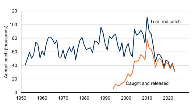
• The total reported rod catch of wild salmon for 2023 is 32,477, the lowest since records began in 1952. This is a decrease of 24% compared to 2022, and 77% of the previous five-year average.
• Catch and release in 2023 accounted for 96% of the total rod catch and 99% of the rod-caught spring multi sea-winter fish (taken before 1 May).
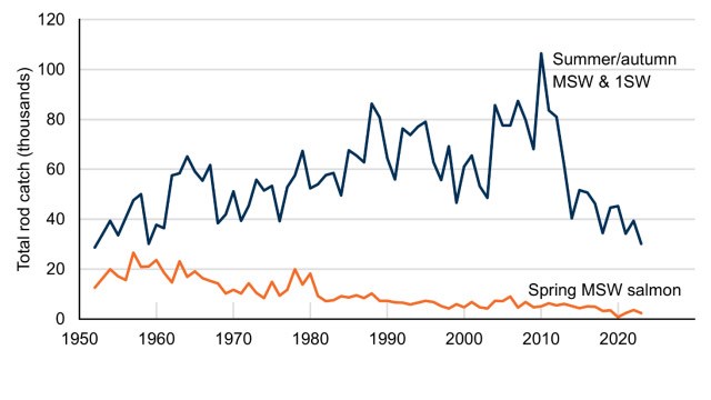
• The reported spring catch in 2023 is 2,366. This is a decrease of 35% on the 2022 season and was 89% of the previous five-year average.
Visualising Declining Salmon Stocks
We are all aware of the threat to Atlantic salmon, and we have all surely heard many times, about the catastrophic collapse of sea trout stocks on the West Coast, attributed to salmon farming, and the gradual decline of salmon catches there also. But without living or fishing there, or spending long hours doing research, it can be difficult to visualise the scale of this. How many rivers are there on the West Coast, how many are affected, what actually are the catch numbers?
If you are curious, head to the West Ross-shire page. Turn on the new Salmon Fisheries layer and click through the rivers up and down the West Coast, particularly the lesser ones, and view the 5-year catch graphs...!